India Atlas 4.2.0
Free Version
Indian Atlas – Your Ticket to Maps of Indian States and Districts
India Atlas is a handy app which lets you view various types of maps of India as well as the maps of states and districts of India on your Smartphone. If you have been looking for a way to view detailed maps of India and its different districts and states then this Indian Atlas is the app that you should be downloading on your phone. It offers you the opportunity to view maps of India detailing its various features. India Atlas has a user-friendly interface and an intuitive design and layout, making it an extremely easy app to use. You will have no trouble in navigating this app and utilizing the features it has in store for you.

India Atlas offers a list of the different states of India whose map you can view on its home screen. The names of the Indian states are listed in alphabetical order. You can view the maps of each state by clicking on its name. The map of each Indian state is quite detailed in nature and marks out each of its districts. All the districts are given a different color so that you can easily identify them. You can view the map more closely by using the pinch-to-zoom feature. The map of each individual district can also be viewed by clicking on it on the state map.
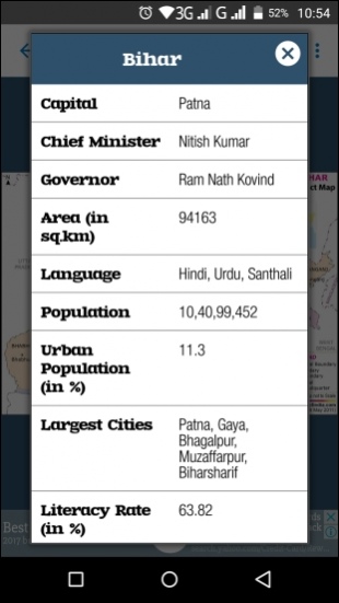
This mobile Indian Atlas gives you the chance to get important information about the state whose map you are viewing. In order to see this information, you will have to click on the button present at the top-right corner of the screen and choose the Information option from the drop-down menu that appears. The information statistics that you get to see for each Indian state include its capital, the name of its Chief Minister, the name of its Governor, its area, the languages that are spoken there, its population, the percentage of its urban population, names of its largest cities and its literacy rate.
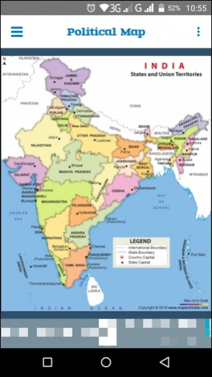
India Atlas offers a drop-down menu option on its home screen as well. This menu can be used for viewing the different kinds of maps of India that this app has to offer you. The types of maps of India you will find listed in this menu include Blank Map, Geographical Map, Outline Map, Physical Map, Political Map, River Map, Railway Map and Tourist Map.
The Blank map is a simple map of India without any state boundaries. The geographical map you see in this Indian Atlas provides a geographical look of the country while the outline map marks out the boundaries of each Indian state on the map without labeling them. The physical and political maps provide information regarding the physical features of the country and its various states and their capitals respectively. The river map lets you have a look at the different rivers that flow through the country while the railway map provides information regarding the country's rail routes. The tourist map lists down the locations of the tourist centers and the national parks that are located throughout India.
Each of these maps can be saved to your device, bookmarked, shared on social networking websites and printed using a wireless printer.

Features:
- User-friendly interface
- Intuitive layout and design
- Various types of maps of India
- Detailed maps of states and districts of India
- Information available for each state
- Bookmark feature
- Option for downloading maps on device
Conclusion:
India Atlas is an app directed towards people who are interested in learning more about India and its geographical location. It offers detailed maps of India and its various states and districts. You get to see maps detailing the rivers, train routes and physical features of India. It is a decent app to have on your Smartphone if you are planning on visiting India.
Our Recommendations